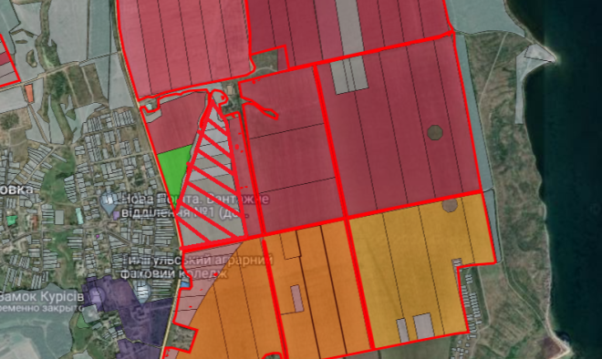
Investment Site Questionnaire – GREENFIELD Type
1. General Information
1.1 Name, location, and site photos: Village of Kurisove
1.2 Geographic coordinates (latitude, longitude): 46.960732, 30.921473
1.3 Distance from the site to the residential zone boundary of the nearest settlement (according to the settlement’s development plan) (km): 0.200 km
1.4 Name and distance to the nearest district center and regional center (km):
- District center: Berezivka, 35 km
- Regional center: Odesa, 60 km
1.5 Total site area (ha): 27.8 ha- 1.5.1 Are there underground obstacles on the site? –
- 1.5.2 Are there above-ground obstacles on the site? –
1.6 Environmental requirements and restrictions (describe if any): Protective zone along the energy system facility - 1.6.1 Soil, surface water, and groundwater contamination (describe examples and risks): –
- 1.6.2 Flooding during high water (describe examples and risks): No
1.7 Proposals for potential land use: –
Additional information: –
2. Legal Status
2.1 Owner: LLC “Kuris Energy”
2.2 Form of ownership: Private
2.3 Available ownership documents (indicate which): Ownership record number 24208950
2.4 Cadastral number (if available): 5122784600:01:002:0743
2.5 User: LLC “Kuris Energy”
- 2.5.1 Purpose of land use: 01.01 Commodity agricultural production
2.6 Is the site within or outside the settlement boundary? Outside the settlement boundary
2.7 Availability of urban planning documentation (territory planning scheme for the district, region, or parts thereof, settlement’s general plan, detailed territory plan, etc.): General plan of the village of Kurisove
2.8 Classification of the land use designation (name, code of the Ukrainian Land Classification):
14.01 For the placement, construction, operation, and maintenance of buildings and structures of energy-generating enterprises, institutions, and organizations
3. Transport and Engineering Infrastructure
3.1 Availability of access road (describe road surface, width): Asphalt surface and gravel embankment, width 6 m and 3 m
3.2 Distance to a state or international highway (km): 0.100 km
3.3 Name of the nearest freight railway station and distance by road to the site (km): Serbka, 25 km
3.4 Information about gas transportation network connection:
- 3.4.1 Distance to the operating gas pipeline (km): 0.500 km
- 3.4.5 Distance to the operating gas distribution station (GRS) (km): 0.500 km
3.5 Information about electricity network connection: - 3.5.1 Distance to the operating power transmission line (PTL) (km): 0.100 km
- 3.5.2 Voltage of the power transmission line (kV): 110
3.6 Water supply: - 3.6.1 How water supply can be provided to the site (indicate possible options): Install a water pipeline
- 3.6.2 Distance to the potential connection point to the existing water pipeline (km): 1 km
3.7 Wastewater (sewage): - 3.7.1 How wastewater can be provided at the site (describe options): Septic tank
- 3.7.2 Distance to the potential connection point to the existing wastewater system (km): 1 km
- 3.7.3 Do sewer water lines (collectors) discharge to operating treatment facilities? No
4. Communication Networks
4.1 Is it possible to provide landline telephone communication? Yes
4.2 Is there stable mobile phone coverage on the site, and by which operators? Yes
5. Contacts
5.1 Institution/organization, address, phone, email:
Kurisovska Amalgamated Territorial Community
28 Partizanskoyi Slavy St., Kurisove Village, Berezivka District, Odesa Region, 67512
Phone: (04855) 9 6580, (04855) 96592
Email: [email protected]
More opportunities in Odesa region
More opportunities in Fuel and Energy
Invest in Ukraine now
In case you have any questions about the Investment Map or would like to receive advice on investment opportunities, please contact us at [email protected]


